language
En Ku Ar

Image Title calendar2024-01-28

In the land of the highlanders: from the kingdom of Simurrum to Mazamua in the Shahrizor

In the late third and early second millennium bc, the large plain known today as the Shahrizor and its surrounding region, located in the province of Suleymaniyah in Iraqi Kurdistan, likely formed an important region of the kingdom of Simurrum (Fig. 31.1; Altaweel et al. 2012). For much of the remaining second millennium bc and into the irst two centuries of the irst millennium bc, the region was a contested border zone between northern and southern Mesopotamian kingdoms or became splintered into small kingdoms.

Image Title calendar2025-01-17

Halaf and Late Chalcolithic occupations at Shakar Tepe in the Shahrizor Plain, Iraqi Kurdistan: Preliminary report of the 2023 excavations

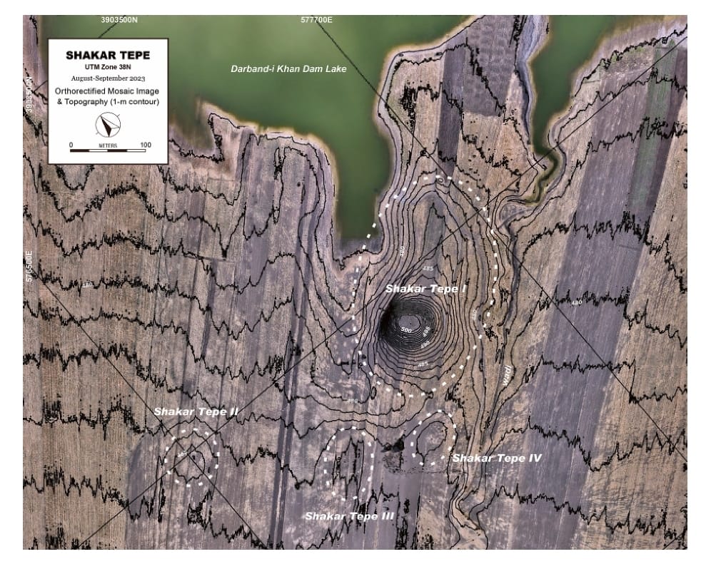
The Shahrizor Plain is one of the ideal fields for tracking the transition from Neolithic village life in the Fertile Crescent to Urbanisation which occurred in Mesopotamia because of its geographical location connecting the mountainside valleys along the Zagros and the downstream Diyala River that flows into the Tigris. Our field project aims to obtain archaeological materials to unveil this process. Following the first excavations at Shakar Tepe conducted in 2019, we excavated two additional areas at this site in 2023, including one of the three satellite mounds that were newly identified around the main mound. The cultural remains of the Late Halaf settlement uncovered from Operation B at Shakar Tepe II date back to approximately 5600–5400 calBC. On the other hand, Operation C at Shakar Tepe I yielded a thick deposit of the Late Chalcolithic occupations dated to ca. 3800–3600 calBC. The recovered materials fill the time ranges in the late prehistoric chronology of the site and will contribute to our understanding of the historical role of this region in the transition from Neolithisation to Urbanisation.

Image Title calendar2024-01-11

Darband-i Rania Archaeological Project, with an area in excess of 70 ha a special interest in the first millennium BC

Darband-i Rania Archaeological Project the Darband-i Rania Archaeological Project was a project directed by Dr. John MacGinnis of the British Museum, carried out in co-operation with the General Director of Antiquities of Kurdistan, the Directorate of Antiquities and Heritage of Raparin and the Directorate of Antiquities and Heritage of Slemani.

Opening a scientific course for training and teaching in photogrammetry program

Article Name

Training course on photogrammetry program was held from 18/2/2024 to 23/2/2024 in Slemani.  The course was taught by archaeologist Tiago Costa for a few days.  In the course, students were taught in practice and theory on the use of the program (Meta shape) to create 3D images, as well as how to photograph archaeological pieces and use drones for archaeological work.  

Then create a contour map of the archaeological site and restore the heritage houses.  

During the course, the students worked on the photographs of the archaeological pieces in the Slemani Museum and then the photos were taken by drone on the archaeological hill of Tapa Kal in Zhala village in southeastern Slemani.

The course was attended by several students from from Slemani Directorate of antiquities and heritage, Slemani University-department of Archeology and cultural heritage organization.

 At the end of the course, certificates were awarded to all participants.

 The supervisors of the course have previously opened similar courses in the cities of (Mosul, Baghdad and Nasiriyah).  The partners of this project so far are:

Creative Europe – STATE BOARD FOR ANTIQUITIES & HERITAGE, IRAQ – The Fact stories – SAPIENZA UNIVERSITY OF ROME – carare – doppel – University of Slemani – Slemani Antiquities & Heritage Directorate

 To learn more about previous activities in different places, please visit this website.  T4H – Training local people in 3D digitization of Cultural Heritage in Iraq (tech4heritage.com).