language
En Ku Ar

Image Title calendar2025-01-17

Halaf and Late Chalcolithic occupations at Shakar Tepe in the Shahrizor Plain, Iraqi Kurdistan: Preliminary report of the 2023 excavations

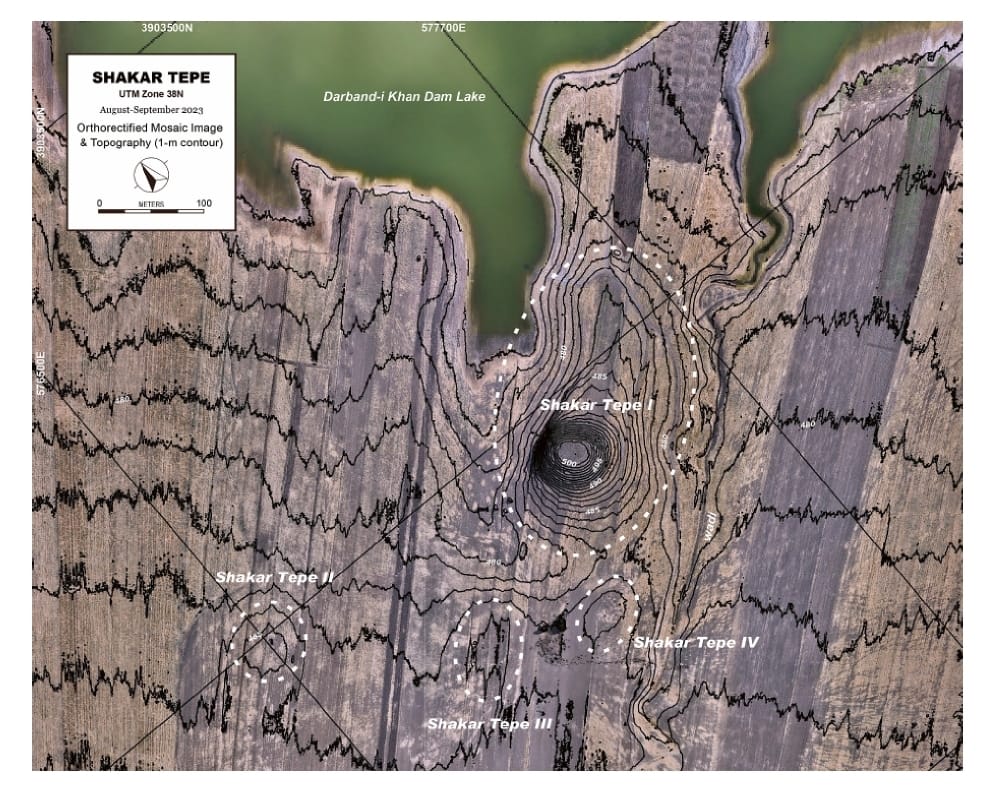
The Shahrizor Plain is one of the ideal fields for tracking the transition from Neolithic village life in the Fertile Crescent to Urbanisation which occurred in Mesopotamia because of its geographical location connecting the mountainside valleys along the Zagros and the downstream Diyala River that flows into the Tigris. Our field project aims to obtain archaeological materials to unveil this process. Following the first excavations at Shakar Tepe conducted in 2019, we excavated two additional areas at this site in 2023, including one of the three satellite mounds that were newly identified around the main mound. The cultural remains of the Late Halaf settlement uncovered from Operation B at Shakar Tepe II date back to approximately 5600–5400 calBC. On the other hand, Operation C at Shakar Tepe I yielded a thick deposit of the Late Chalcolithic occupations dated to ca. 3800–3600 calBC. The recovered materials fill the time ranges in the late prehistoric chronology of the site and will contribute to our understanding of the historical role of this region in the transition from Neolithisation to Urbanisation.

Image Title calendar2024-01-29

Excavations at Shaikh Marif, Iraqi Kurdistan Preliminary Report of the First Season (2022)

Grdi-Shaikh Marif The archaeological site of Shaikh Marif, located in the Shahrizor Plain ca. 500 m south of Gird Shamlu along the Wadi Shamlu, was registered by the Iraq Museum in 1943. In November 2012, the Shahrizor Survey Project additionally identified several new artificial mounds near Shaikh Marif. Among them, a cluster of two tiny mounds is called, together with Shaikh Marif itself, “Se Tapanسێ تەپان ” by the local people, and thus all three mounds were designated “Shaikh Marif”: Shaikh Marif I (the original northern mound), Shaikh Marif II (a western mound also called “Ash Shaikh Marif” by the locals), and Shaikh Marif III (an eastern mound). The land is seasonally cultivated today, and the water of the Darband-i Khan Dam Lake occasionally covers almost entire areas of the mounds. Owing to modern cultivation and the erosion by flowing water, a large amount of archaeological materials were easily observed on the surface. While no prehistoric material was identified at Shaikh Marif III, numerous Late Neolithic potsherds were scattered across the other two mounds as well as the materials dated to the younger periods. The date of these Late Neolithic sherds was estimated to be ca. 6400 6000 BC. A Japanese archaeological team (directed by Takahiro Odaka, Kanazawa University) excavated Shaikh Marif II in 2022 and revealed the Late Neolithic layers, which directly accumulated on the virgin soil. Most of the finds were dated to ca. 6100-6000 BC, although a small amount of the artefacts from the historical periods indicate human activities in the middle Medieval and the Ottoman Periods.

Image Title calendar2024-01-11

Darband-i Rania Archaeological Project, with an area in excess of 70 ha a special interest in the first millennium BC

Darband-i Rania Archaeological Project the Darband-i Rania Archaeological Project was a project directed by Dr. John MacGinnis of the British Museum, carried out in co-operation with the General Director of Antiquities of Kurdistan, the Directorate of Antiquities and Heritage of Raparin and the Directorate of Antiquities and Heritage of Slemani.

Darband-i Rania Archaeological Project, with an area in excess of 70 ha a special interest in the first millennium BC

Article Name

Darband-i Rania Archaeological Project the Darband-i Rania Archaeological Project was a project directed by Dr. John MacGinnis of the British Museum, carried out in co-operation with the General Director of Antiquities of Kurdistan, the Directorate of Antiquities and Heritage of Raparin and the Directorate of Antiquities and Heritage of Slemani. The aim of the project was to explore the occupation of the pass through the fortified systems constructed to defend it, with a special interest in the first millennium BC. The permit granted by the General Directorate allowed the investigation of three sites, Qalatga Darband, Usu Aska and Murad Rasu.

Qalatga Darband

Qalatga Darband is the largest of the sites investigated, with an area in excess of 70 ha. Enclosed by fortifications, all dating to the early Parthian period. The two most prominent buildings investigated were (i) a large square fort situated within the wider fortified area, identified through satellite imagery, mapped by geophysical prospection ground-truthed by targeted excavations; and (ii) a monumental manor house measuring 23 m square, with a lower storey built of stone walls with alternating square and circular columns on the outer phase, and an upper storey of mud brick, the building was rooved with Mediterranean-style terracotta roof tiles. The most striking finds in the building are the remains of Hellenistic sculpture, the most notable of which a statue of a naked male are and a statue of a seated female.

Usu Aska

 The second site to be investigated was Usu Aska, a fort inside the pass itself, on the southern side, dated to the Neo-Assyrian period. The site consists of massive fortification walls connected to a fortified knoll (now an island when the lake is high) at the northeastern end. The successive jumbles of collapsed masonry, particularly on the inner (mountain) side, show that the fortification were damaged by earthquakes and subsequently rebuilt on multiple occasions.

Murad Rasu

The last site to be investigated was Murad Rasu, a traditional mounded site which has suffered heavy erosion from the waters of Lake Dokan. Murad Rasu has occupations from the Uruk period to the Ottoman period (not necessarily continuous). The most alluring feature is the remains of a palace built of mud brick and tentatively dated to the early second millennium BC. The one room excavated to date was full of massive pithoi storage jars, very likely a magazine for storing of grain controlled a local administrative authority.